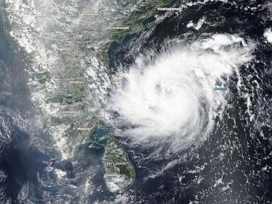
Getting hit by one major storm is bad enough. Taking two devastating punches in less than seven days feels unfair, yet that's the brutal reality facing eastern India right now.
Heavy rains are lashing the coastline today after Cyclone Murasu slammed ashore near Ongole in Andhra Pradesh. Maximum sustained winds reached up to 110 kilometers per hour, ripping up trees, downing power poles, and inundating low-lying neighborhoods. If you're wondering how a region can even begin to recover when the ground is already saturated, you're looking at the right question. The system follows hot on the heels of Cyclone Arnab, which battered the exact same state just last week.
The Double Blow on the Bay of Bengal
The Bay of Bengal acts like a giant atmospheric pressure cooker. Warm waters frequently brew dangerous tropical systems during the transition months. But seeing two cyclones spawn and strike land within a single week is an exhausting ordeal for local communities and disaster management teams.
Cyclone Arnab left a painful trail last Wednesday, killing at least five people, damaging infrastructure, and wiping out roughly 200,000 acres of vital cropland. Before farmers could even assess their ruined fields or patch up damaged roofs, weather forecasters were tracking Cyclone Murasu moving across the water.
When Murasu made landfall near Prakasam district, it packed sustained winds of 100 to 110 kph, with sharper gusts tearing through the region. The India Meteorological Department warned of potential storm surges reaching up to 1.5 meters along vulnerable coastal stretches.
Evacuations and Emergency Response
Authorities didn't wait around for disaster to strike twice. Learning hard lessons from past storms, local governments moved quickly. Thousands of residents in high-risk zones were evacuated to safer shelters ahead of the landfall.
Schools shut down early. Train services and select flights faced immediate cancellations to keep people off the roads and tracks. Prakhar Jain, managing director of the Andhra Pradesh State Disaster Management Authority, noted that timely evacuations helped prevent immediate casualties, with no deaths or serious injuries reported in the hours immediately following Murasu's landfall.
Still, infrastructure takes a brutal beating even when lives are spared. Power lines are down. Secondary roads are blocked by debris and floodwaters.
The Broader Climate Reality
Why are these rapid-fire storms happening? Scientists point to warming ocean temperatures and shifting weather patterns, including the lingering influence of El Niño, which continues to warm waters and alter pressure zones across global basins. The Bay of Bengal has always been a hotspot for severe weather, but the frequency and tight clustering of these intense systems stretch emergency response capabilities to their absolute limits.
Recovery isn't just about weathering the wind. It's about surviving the aftermath. Stagnant floodwaters breed waterborne diseases. Destroyed crops mean massive economic losses for agrarian families who live season to season.
Relief teams are already moving into the hardest-hit districts to clear roads and restore electricity. But as the floodwaters slowly recede, eastern India faces a long, difficult road back to normal.